Web application solutions provide specialized 2D and 3D mapping and spatial capabilities that are accessible globally through the Internet. By leveraging the latest capabilities of modern browsers, web applications can create sophisticated visualizations that help users understand complex data and spatial relationships. They can also improve and streamline workflows and support more informed decisions.
Web application solutions have changed the way geographic content and spatial analytical capabilities are delivered. These solutions are easy to deploy, maintain, update, and use. They are perfect for users and markets that don’t need detailed technical knowledge or training.
Capabilities utilized
2D/3D maps
Search and geocoding
Location-based apps
Data hosting
Identity-based permissions
Spatial analysis
Use cases
Operational awareness
Integrate real-time data (like traffic and weather) with information from partners and internal business systems to deliver the most current assessment possible. Operational awareness solutions help customers make more informed decisions that can save lives and property.
Real estate
Use maps and spatial analysis to supplement experience and intuition with powerful insight. Help users quickly understand and capitalize on market opportunities. Amplify market knowledge with location-based data to support site selection, marketing, and store location.
Public outreach
Combine authoritative maps and data with narrative text, images, and multimedia content. These solutions harness the power of maps and geography to engage communities, communicate with customers, educate decision-makers, and involve constituents.
Previous
Next
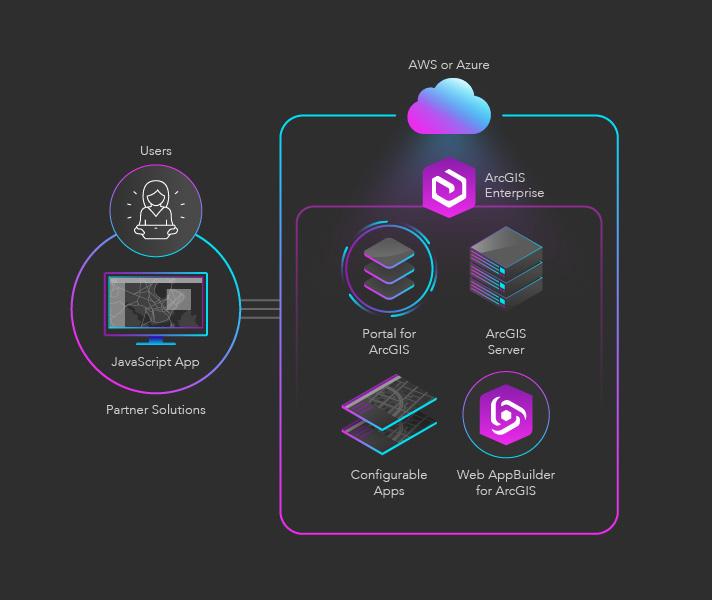
Conceptual architecture
Description of components
ArcGIS Enterprise: A complete GIS that runs behind your firewall in your enterprise or on cloud infrastructure like Amazon Web Services (AWS) or Azure
Partner Solutions: Custom web, mobile, and desktop apps that enable advanced data visualizations, built using ArcGIS development APIs and SDKs
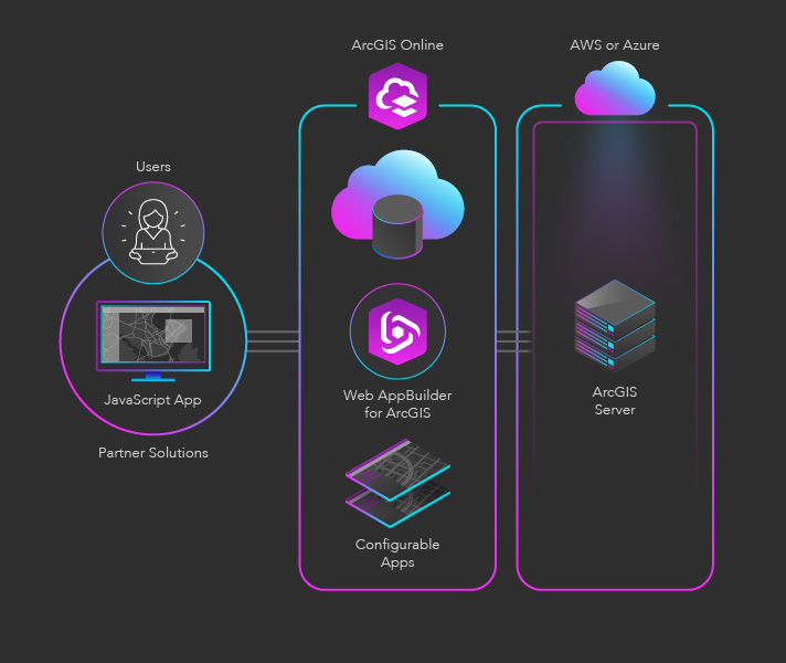
Description of components
ArcGIS Enterprise: A complete GIS that runs behind your firewall in your enterprise or on cloud infrastructure like AWS or Azure
ArcGIS Online: A complete cloud-based mapping and analysis solution
Partner Solutions: Custom web, mobile, and desktop apps that enable advanced data visualizations, built using ArcGIS development APIs and SDKs
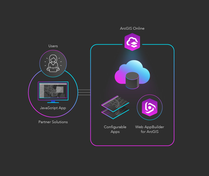
Description of components
ArcGIS Enterprise: A complete GIS that runs behind your firewall in your enterprise or on cloud infrastructure like AWS or Azure
ArcGIS Online: A complete cloud-based mapping and analysis solution
Partner Solutions: Custom web, mobile, and desktop apps that enable advanced data visualizations, built using ArcGIS development APIs and SDKs